
Goeldner Woods is managed as a multi-use recreation area with a small picnic area near the parking lot and an extensive trail system that explores all corners of the park. This 44 acre park is primarily upland hardwood forest with some bottom land timber on the north end of the park adjacent to the North Branch of North River. One of the most unique aspects of Goeldner Woods is the annual spring woodland wildflower display. Due to cool north facing woodland slopes and rich virgin soils, this area explodes into pastel color tones as the forest floor literally is blanketed with millions of wildflower blooms. Over 60 species of woodland flowers have been identified.
Facilities & Features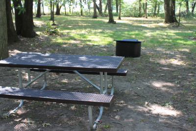
- 40 Acre Timber
- Picnic Area
- Pit Vault Bathroom
- Hiking Trails
Activities
Public Hunting: Even though there is only 40 acres of timber available for public hunting, Goeldner Woods is surrounded by large tracts of privately owned high quality upland forest in this North River valley. Excellent location for White-Tailed deer, turkey, squirrel and other small woodland game. Not bad for mushrooms either!
Hiking: Trails meander through the entire park. The upper loop (approximately 1/2 mile) is located adjacent to the picnic grounds and remains primarily on level ground in the upper elevations of the park. The lower loop trail system (1 1/2 miles) explores the side slopes and river bottom timber and traverses steeper gradients.
Nature Study & Photography: The wide variety of spring time woodland wildflowers makes this a “must see” area in late April and early May. This is also an excellent area for birding throughout the year. Special Note: The rare flying squirrel is an inhabitant of Goeldner Woods.
Picnicking: A small picnic area with ground grills and fireplaces is available adjacent to the parking area.
Directions
Goeldner Woods is located approximately 5 miles southeast of Earlham in the northwest corner of Madison County. From Winterset travel north on U.S. 169 approximately 5 miles, turn west on 152nd Street for 2 miles, turn north on Hogback Bridge Ave. for 3/4 mile, turn west and follow Juniper Trail west and north for 2 1/4 miles. From Earlham travel east on 1st Street, turn south on Heritage Ave. for 1/2 mile, turn east on 115th Street for 1 1/2 miles, turn south on Ivy Ave. for 1 mile, turn east on 120th Street for 1/2 mile and turn south on Juniper Trail for 1 mile. Both routes are marked by standard County Park arrowhead signs at intersections.
911 Address: NA
GPS Coordinates (UTM @ parking lot): X:409760 Y:4589654, UTM Zone 15